


NEW DELHI: India’s rapidly growing aerospace capabilities, backed by cost-competitive manufacturing, deep engineering talent, and cutting-edge indigenous technologies, are opening new opportunities in the global aviation and space ecosystem. According to a recent Jefferies report, the aerospace sector is now one of the key emerging industrial frontiers where India stands to benefit significantly from the current global demand-supply imbalance.
Major aviation giants like Boeing and Airbus currently source approximately US$1.4 to 1.6 billion annually from India. Simultaneously, domestic companies such as Aequs, Azad Engineering, DYTC, BHFC, Motherson, and Sansera are rapidly expanding their footprints as global original equipment manufacturers (OEMs) and Tier-1 suppliers.
GAGAN: Advancing Aviation Technology
Against this backdrop of manufacturing growth, India’s indigenous GAGAN (GPS Aided GEO Augmented Navigation) system represents a monumental development in advanced aviation technology.
Developed jointly by the Indian Space Research Organisation (ISRO) and the Airports Authority of India (AAI), GAGAN is a Satellite-Based Augmentation System (SBAS). The system significantly improves GPS accuracy and provides crucial integrity information, ensuring safer aircraft navigation across Indian airspace and beyond.
Fully operational since 2015, the system places India among a highly select group of countries—alongside the US, Europe, and Japan—with an operational SBAS. In a major recent milestone, the Directorate General of Civil Aviation (DGCA) successfully conducted India’s first satellite-based landing system approach on a commercial jet aircraft using GAGAN in June 2026.

Indigenous Navigation Infrastructure
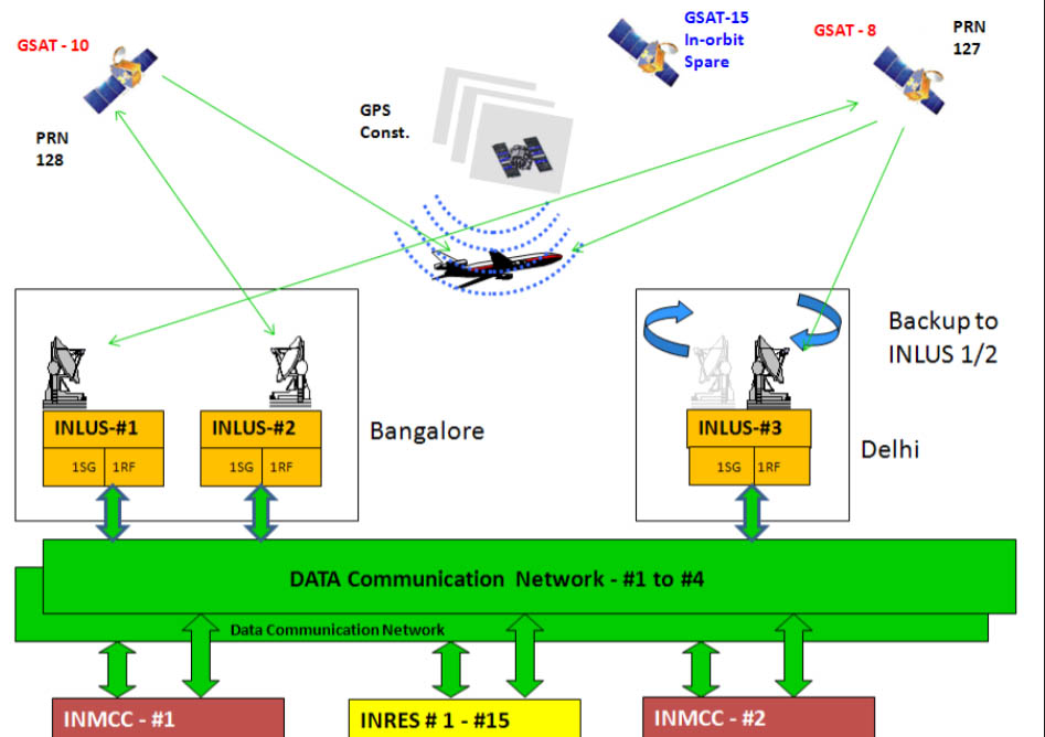
The GAGAN system operates through a robust, integrated network comprising 15 Indian Reference Stations, two Indian Master Control Centres, and three Indian Land Uplink Stations. This ground infrastructure is supported by seamless communication networks and three geostationary satellites—GSAT-8, GSAT-10, and GSAT-15—which carry the vital GAGAN payloads.
These satellites broadcast corrected navigation signals and real-time integrity information directly to users. Notably, GAGAN is the first SBAS certified for the equatorial region and remains fully interoperable with other international systems, including the US WAAS, Europe’s EGNOS, and Japan’s MSAS.
While NavIC (Navigation with Indian Constellation) serves as India’s indigenous regional navigation system—providing positioning, navigation, and timing services across India and up to 1,500 km beyond its borders—GAGAN specifically complements it by enhancing GPS signals for highly precise aviation navigation.
Global Reach and Beyond Aviation
India’s broader navigation ecosystem is increasingly gaining international reach. Strengthening its global cooperation in satellite-based navigation, India signed a landmark agreement with South Africa in 2025 to establish a NavIC reference station.
Beyond the aviation sector, GAGAN’s technology holds immense potential for applications across various industries, including:
-
Maritime Navigation: Accurate positioning in coastal waters.
-
Road Transport & Railways: Supporting intelligent transport systems and operational efficiency.
-
Disaster Management: Enabling accurate location tracking during emergencies.
-
Defence, Telecom, and Surveying: Strengthening security operations and synchronizing telecom infrastructure.
The continued development of GAGAN, coupled with India’s rapidly expanding aerospace manufacturing base, strongly reflects the broader industrial shift highlighted in the Jefferies report—a strategic transition from domestic capability-building toward higher-value technology, integration into global supply chains, and greater indigenous value addition.
Keywords: GAGAN Navigation System, ISRO Aerospace, Jefferies India Aerospace Report, Indian Aviation Suppliers, AAI Satellite Navigation, NavIC